PR 2FCMP Certified
PR 2 - Vereda do Urzal
Câmara de Lobos, Madeira(Freguesia de Boaventura)
Info updated 51 days ago
Status
Open
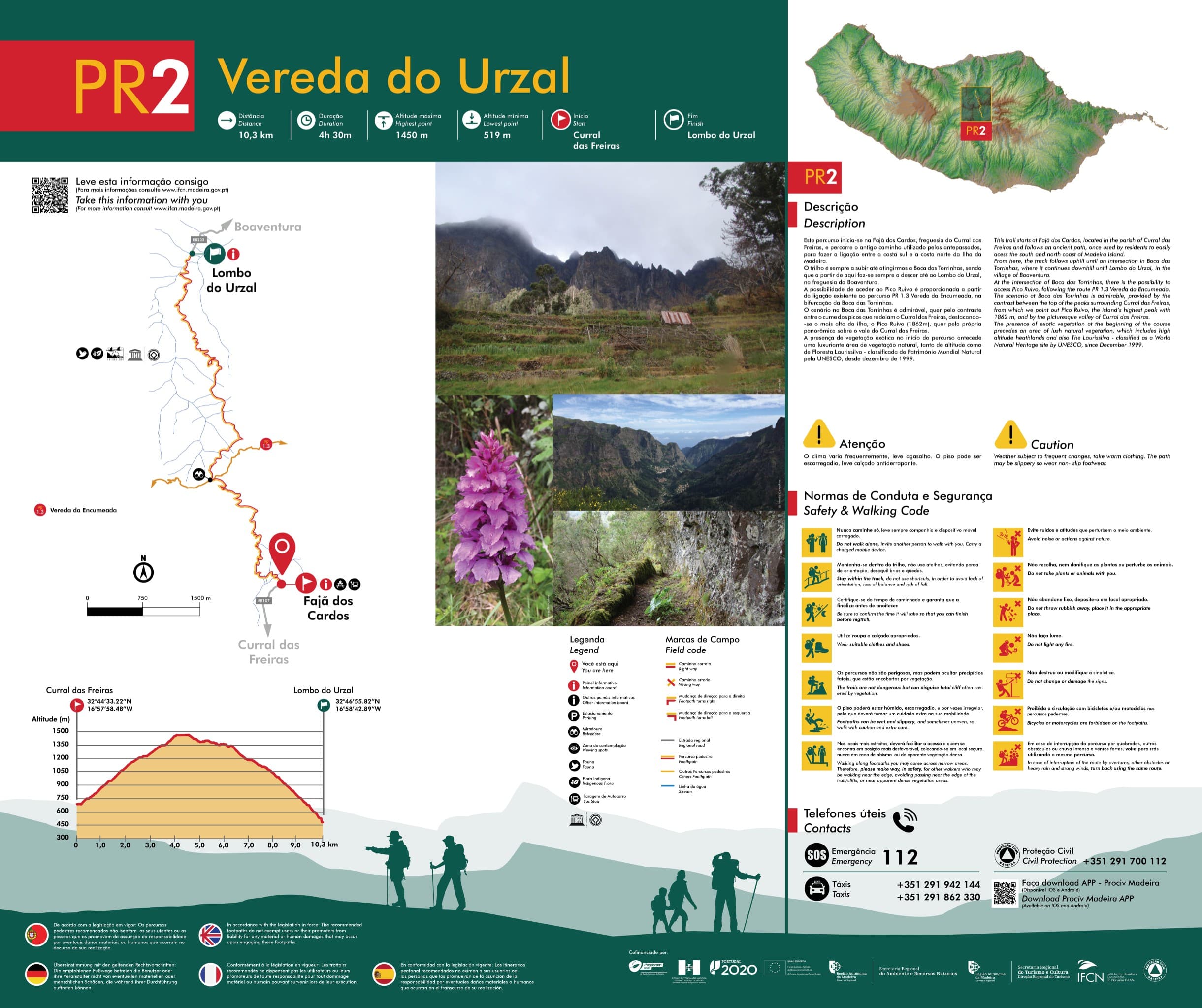
Distance
10.3 km
Duration
4h30
Difficulty
HardType
Linear
Classification
PR
Official code
PR 2
GPX track
Unavailable
About the trail
This trail begins at Fajã dos Cardos, in the parish of Curral das Freiras, and follows the old path used by our ancestors to connect the south and north coasts of Madeira Island.
The trail climbs continuously until reaching Boca das Torrinhas, from where it descends all the way down to Lombo do Urzal, in the parish of Boaventura.
Access to Pico Ruivo is possible through the existing connection to trail PR 1.3 Vereda da Encumeada, at the Boca das Torrinhas junction.
The scenery at Boca das Torrinhas is remarkable, both for the contrast between the peaks surrounding Curral das Freiras, featuring the island's highest point, Pico Ruivo (1862m), and for the panoramic view of the Curral das Freiras valley itself.
The presence of exotic vegetation at the beginning of the trail precedes a lush area of natural vegetation, including both high-altitude plants and Laurissilva forest - classified as a UNESCO World Natural Heritage site since December 1999.
Surface
Terra batidaRocha
Permitted activities
✓Hiking
✓Caminhada
Code of Conduct
- Never hike alone, always bring company and a charged mobile device;
- Avoid noise and behavior that disturbs the environment;
- Stay on the trail, don't use shortcuts, avoiding loss of orientation, imbalance and falls;
- Do not collect or damage plants or disturb animals;
- Make sure of your hiking time and ensure you finish before nightfall;
- Do not litter, dispose of waste in appropriate places;
- Wear appropriate clothing and footwear;
- Do not make fires;
- The trails are not dangerous, but may conceal fatal precipices that are hidden by vegetation;
- Do not destroy or modify signage;
- The ground may be wet, slippery, and sometimes uneven, so take extra care with your mobility;
- Bicycles and/or motorcycles are prohibited on pedestrian trails;
- In narrower sections, facilitate access for those in more disadvantageous positions by positioning yourself in a safe place, never near cliffs or areas of apparently dense vegetation;
- In case of trail interruption due to landslides, other obstacles, or heavy rain and strong winds, turn back using the same route.
Useful Contacts
SOS
112Centro de Saúde de Câmara de Lobos
291 910 380Divisão Policial da PSP (Câmara de Lobos)
291 110 200Bombeiros Voluntários de Câmara de Lobos
291 914 430Trail information
- Official code
- PR 2
Sources & Official Information
Plan your trip with Travelook
Same accountExplore the region — Câmara de Lobos, Madeira